The Fishing Vessel Observing Network (FVON), Surface Ocean CO2 Observing Network (SOCONET) and Science Monitoring And Reliable Telecommunications (SMART) Subsea Cables are three new emerging networks aiming to grow and contribute to the Global Ocean Observing System by providing sustained and interoperable ocean data to fill known gaps.
Thirteen mature global observing networks currently track changes in ocean conditions under the IOC-UNESCO led Global Ocean Observing System’s (GOOS) Observations Coordination Group. The Observations Coordination Group strengthens the implementation of a global ocean observing system through supporting cross-network coordination and advancing maturity to deliver observations that are interoperable, accessible, and fit for purpose.
Through a variety of different observing platforms such as ships, buoys, gliders and even animal-borne sensors, these networks collect data on variables such as ocean temperature, currents, waves, sea level, salinity, nutrients, carbon and oxygen that are vital to characterizing changes of the global ocean environment. We still, however, face critical gaps in our monitoring of the ocean, and the three new emerging networks aim to reduce these by using already existing infrastructure and cooperating with industry.
FVON: Collaborating with fishers to fill in coastal data ‘deserts’
The GOOS 2030 Strategy and the recently published UN Ocean Decade White Paper on Challenge 7: ‘Expand the Global Ocean Observing System’, both highlight that an increase in sustained observing platforms is needed in coastal areas, especially in regions where ocean observing infrastructure is less developed.
“There are ocean data ‘deserts’ in the coastal areas, where the vast majority of anthropogenic activities occur and where the potential value of ocean data is highest. The Fishing Vessel Observing Network (FVON) aims to fill these data deserts at an unprecedented resolution and scale by partnering with fishers around the world,” says Christopher Cusack of FVON – one of the latest additions to the GOOS observing networks.
More than four million fishing vessels operate globally, mostly in the relatively data-sparse nearshore areas of the ocean. Thus, fishers are ideal partners for data collection in shelf and coastal seas, as they are already operating in these areas and lowering equipment which can host ocean observing sensors into the water during the course of normal operations.
“By collaborating with fishers, FVON seeks to democratise ocean observing – both by including local stakeholders in data collection, and by making ocean observation accessible in resource constrained regions,” says Cusack. “We are thrilled to be a part of GOOS, and are looking forward to future collaborations with other networks. Inter-network collaborations are key for a more harmonized observing system, such that all of our observations have compounding value leveraging the unique strengths of individual networks and capabilities of platforms” he adds.
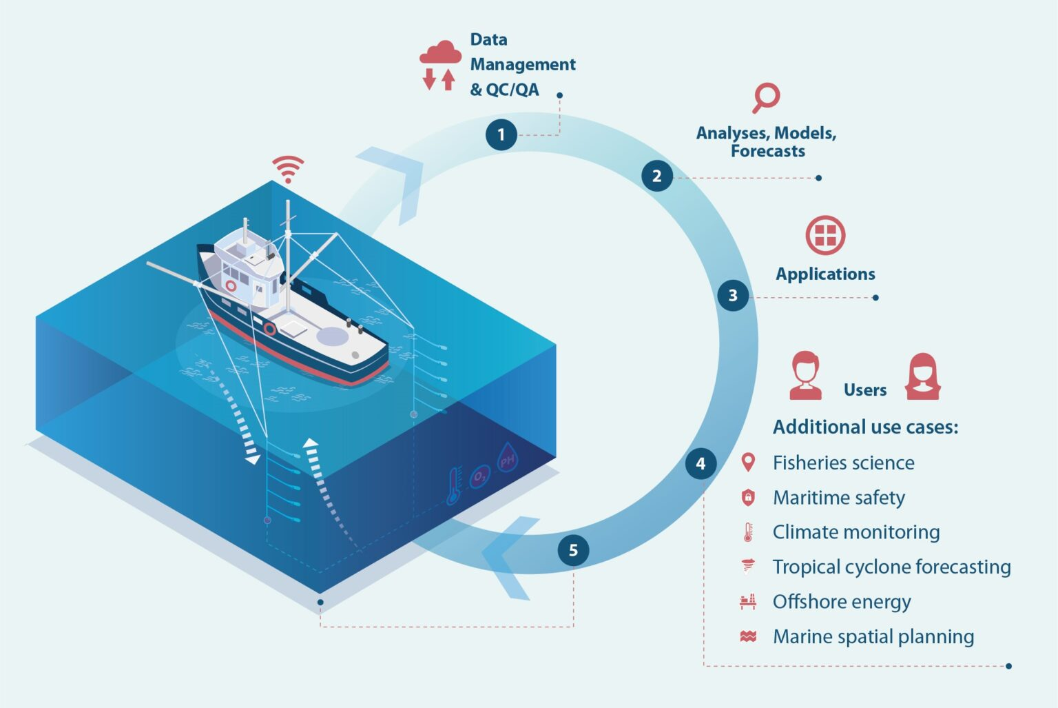
The value chain of the fishing vessel observing data. Source: FVON
SOCONET: Integrating the variety of surface CO₂ monitoring platforms
The Global Carbon Budget reports that in the last decade the ocean alone took up about 26% of carbon dioxide, or CO₂, emitted to the atmosphere every year, thus limiting climate change. However, ocean CO₂ uptake varies significantly in time and space, and robust information about these changes is currently still lacking. A large number of high-quality continuous measurements is needed to monitor and better predict the ever-changing scales and patterns of interactions between air and ocean, and the adverse impacts of this continued CO₂ uptake, such as ocean acidification.
“So far, the fate of human-produced and natural carbon dioxide released into the atmosphere has been addressed by a relatively small and loose affiliation of various observing platforms, from merchant and research vessels, moorings to sailing boats and uncrewed surface vehicles, lacking any formal integration and coordination,” says Maciej Telszewski, interim coordinator of the Surface Ocean CO₂ Observing Network (SOCONET). “This results in limited consideration of the surface ocean carbon observations in the United Nations Framework Convention on Climate Change assessments, the World Meteorological Organization’s Global Greenhouse Gas Watch (GGGW), and other critical management and policy making bodies where this data is vital to our future,” he adds.
SOCONET, the new addition to the GOOS ocean observing networks, aims to expand the number of highest quality surface CO₂ observations, leading to monthly air-CO₂ flux maps for the GGGW, needed to assess ocean health related to acidification, and quantify the ocean’s mitigation potential to reduce atmospheric CO₂ increases.
“As a formalized and coordinated network integrated within relevant elements of IOC-UNESCO and the World Meteorological Organization, SOCONET will be the backbone of monitoring efforts to properly incorporate ocean carbon sinks in global carbon assessments and stocktakes, as well as assess marine carbon dioxide removal interventions at scale,” says Telszewski.
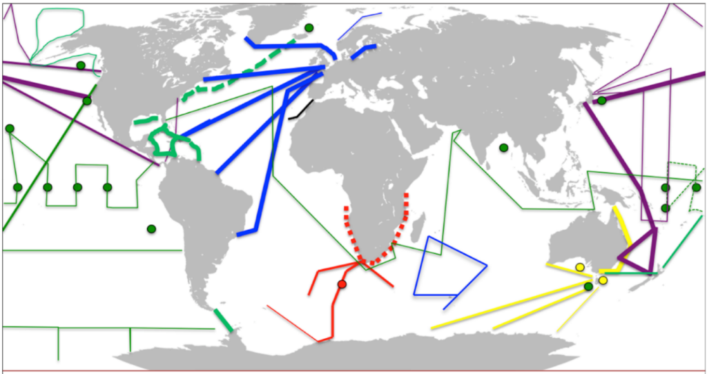
Distribution of lines and moorings that meet SOCONET quality and (meta)data criteria (as of 2018). Lines show vessel routes, while dots show moorings. Colours indicate countries that operate each platform: Green – USA, purple – Japan, Blue – Pan European countries, yellow – Australia, red – South Africa, black – others. Dashed lines symbolize planned initiatives. Source: SOCONET
SMART Cables: Maximizing the societal benefits of subsea infrastructure
A network of subsea telecommunications cables has been used since the mid-19th century to enable international phone calls, data transfers, high-speed internet connectivity, and other telecommunications services between countries. Now, the observing community is aiming to make use of such cables for improved tsunami detection and climate research.
“A SMART (Science Monitoring And Reliable Telecommunications) Cable System combines the functionality of a telecommunication cable with environmental sensing by equipping the cables with three types of ocean bottom sensors that collect data on temperature, bottom pressure and seismic motion,” says Ceci Rodriguez Cruz, Director of the SMART Cables International Programme Office.
The SMART Cables network will contribute to GOOS by filling observing gaps in the deep ocean on the global scale with reliable, real time, long-term measurements. Taking a long perspective across the 25-year lifetime of SMART Cables, the cost is modest – and the benefits can be priceless.
“This real time data will allow operational and multi-hazard warning centers in Small Island Developing States, Least Developed Countries, Developing and Developed countries to improve their services and provide local communities with the long term reliable infrastructure to save lives, for example through improved tsunami warnings. It will enable the local, regional and global science communities to enhance our understanding of the ocean and Earth system, such as ocean heat content, circulation, sea level rise as well as geophysics,” says Rodriguez Cruz.
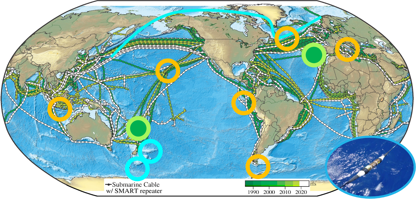
The distribution of current and planned cables. Portugal’s Atlantic CAM SMART Cable and the Vanuatu-New Caledonia SMART Cable (green circles) will be ready for service in 2026. Other symbols show cable systems under consideration. Source: SMART Cables
What’s next?
The three new emerging networks now under the coordination of GOOS Observations Coordination Group are all on a path towards becoming fully mature networks that will contribute data routinely to the global system.
“GOOS is excited to see the three networks are addressing different gaps in our ocean observing system, exploiting existing marine systems, and closely collaborating with different industry sectors,” says David Legler, Chair of the GOOS Observations Coordination Group. “We invite the ocean community to watch this space as we continue to report on these exciting developments.”
—
About GOOS:
The Global Ocean Observing System (GOOS) is the global home of ocean observing expertise. We lead and support a community of international, regional and national ocean observing programmes, governments, UN agencies, research organizations and individual scientists. Our Core Team of expert panels, networks, alliances and projects, supported by the GOOS Office, is in touch with ocean observing and forecasting around the world. We are a programme led by the Intergovernmental Oceanographic Commission (IOC) of UNESCO, with UN and science co-sponsors: World Meteorological Organization (WMO), UN Environmental Programme (UNEP) and the International Science Council (ISC).
About IOC-UNESCO:
The Intergovernmental Oceanographic Commission of UNESCO (IOC-UNESCO) promotes international cooperation in marine sciences to improve management of the ocean, coasts and marine resources. The IOC enables its 150 Member States to work together by coordinating programmes in capacity development, ocean observations and services, ocean science and tsunami warning. The work of the IOC contributes to the mission of UNESCO to promote the advancement of science and its applications to develop knowledge and capacity, key to economic and social progress, the basis of peace and sustainable development.